Lacasse outlined practical strategies landscape architects can apply to reduce the carbon footprint of parks, plazas, residential communities, and other landscapes.
A landscape’s footprint depends on how much concrete, steel, aluminum, and other carbon-intensive materials it incorporates. These materials create high amounts of embodied carbon in comparison with other materials, like wood, which store carbon.
“A highly active urban plaza will have lots of hardscape,” Lacasse said. But designers can still find ways to minimize hard surfaces and structures to reduce climate impacts.
One tool for figuring out how to cut these materials is Climate Positive Design’s Pathfinder. It shows landscape architects the carbon impacts of the materials they choose for a project.
To get there, Lacasse said landscape architects should cut unnecessary concrete surfaces and swap in decomposed granite, local stone or wood pavers, or recycled materials.
Conventional asphalt, which is commonly used in streets and trails, can be swapped for pervious asphalt, which is lower in carbon. Existing asphalt can also be cut and reused.
Reducing high-carbon materials overall provides benefits. “We can rethink our designs. Do you need a 10-foot-wide concrete or asphalt path, or can you make it 5-feet-wide and add decomposed granite to the edges?”
10-foot-wide path and a 5-foot-wide path alternative / LPA Design Studios
“Instead of a concrete seat wall, design a wood one. Instead of concrete retaining walls and terraces, slope the grade,” she said.
Reducing materials with high embodied carbon is one step for reducing emissions from landscape architecture projects. The other side is significantly increasing the amount of carbon stored in a landscape. If the amount of carbon sequestered is more than the amount emitted by its construction or operations, it’s climate positive — a net carbon sink.
Biodiverse landscapes, with layers of trees and understory plants, store more carbon. But maximizing carbon storage in a landscape is complex. “We look at the growth speed and life span of trees and plants, the planting strategy, how to weave in biodiversity,” Lacasse said.
Biodiverse landscapes store more carbon / GGLO
Trees, plants, and soils all store carbon but at different rates. “Evergreen trees have a faster carbon absorption rate. Deciduous trees have larger canopies and denser wood so they store more carbon, but their absorption rate is slower.”
Carbon storage in evergreen and deciduous trees / GGLO
Large trees store more carbon than smaller trees, so it’s important to keep existing trees whenever possible.
Carbon storage by tree age / GGLO
For a new two-acre community in Seattle, with community gathering places, playground, and a creek, GGLO first created a design using conventional concrete, asphalt, and metal play equipment (see images at top).
Using the Pathfinder tool, they found the site would take 92 years to become climate positive. That is how long it would take for the carbon stored in the trees, plants, and soils to be greater than the carbon emitted through the site’s materials and construction.
But with some changes to the design — including recycled asphalt and concrete; bamboo decking; and wood seatwalls, play structures, and surfaces — it could take 32 years to reach climate positive, a decrease of 60 years.
“We can’t manage carbon without measuring it. These tools can make designers feel empowered,” he said.
From his work with the tools, he found that “the decarbonization potential is higher with hardscapes. Reducing the use of these materials is better than pumping up planting. You can’t plant the heck out of a project to offset embodied carbon. Reduce first and sequester second.”
And Mariana Ricker, ASLA, an associate with SWA, explained how landscape architecture firms can weave carbon considerations into their internal design workflow. “It is just another layer in the process.”
To make that workflow clearer, SWA developed its own decarbonization guide. “We use it to advocate to clients, empower our designers, and prioritize. Not all projects have the same carbon potential.”
She urged landscape architects to carefully consider the materials they select for projects. “It’s important to be as low carbon as possible upfront.”
“When a material has been produced, those embodied carbon emissions are in the atmosphere. We have a limited time span with the climate crisis. Reducing emissions must be our priority. Sequestration happens later, over time.”
The gigantic and costly industry Silicon Valley is building around generative AI is still struggling to explain the technology's utility.
Why it matters: AI chatbots and image generators are making headlines and fortunes, but a year and a half into their revolution, it remains tough to say exactly why we should all start using them.
The most common rationale is a kind of circular reasoning: Everyone's going to be using these tools, the argument goes, so you might as well get ahead of the parade.
Driving the news: This spring, a chorus of thoughtful critics has begun sharing the nagging feeling that, fascinating and alarming as generative AI may be, it doesn't have much practical use in their work or lives.
In a recent podcast conversation, New York Times columnist Ezra Klein said, "I consistently sort of wander up to the A.I., ask it a question, find myself somewhat impressed or unimpressed at the answer. But it doesn't stick for me. It is not a sticky habit ... it's not really clear how to make A.I. part of your life."
Software engineer Molly White, author of "Web3 is Going Just Great," reports that generative AI tools are "handy in the same way that it might occasionally be useful to delegate some tasks to an inexperienced and sometimes sloppy intern," but hardly a solid foundation for tech's next big platform.
Tech historian Margaret O'Mara compares today's AI industry to the big business of beaver-skins.
In the 19th century, a bounty of beavers roamed North America, so many that demand for men's top hats drove a vast business in trapping for decades, until beavers were nearly extinct. Then hat-makers figured out how to work with silk instead, which they could have been doing all along.
"I get a beaver-fur hat vibe from some of the AI conversations now," O'Mara told tech journalist Caitlin Dewey. "These companies have so many resources: so much money, so much talent, all these massive data centers, the ability to create incredibly powerful models. And so they are creating those models, and the market is growing to meet them."
"But it's not always apparent if we really need this technology, in every case, or if anyone's asking those questions."
These doubters are not technophobes or Big Tech demonizers — they're experienced observers of the tech world who have voluntarily jumped into the AI pool, only to find it mostly dry.
Flashback: Every other major platform shift in tech — from the personal computer to the internet to the smartphone — also went through a period of everyone asking, "What do I do with this thing?"
Tech historian Laine Nooney's book "The Apple II Age: How the Computer Became Personal" reminds us that it took years for consumers to be persuaded that PCs had broad value beyond the relatively limited initial use cases of spreadsheets and games.
The industry bet on AI is that, as with those previous waves, if you get a new technology into a wide enough set of hands, users will discover what to do with it.
The other side: There is a broad consensus that generative AI already provides clear value in several specific use-cases.
It makes a great coding assistant, relieving some drudgery in the programmer's life and providing help with unfamiliar details and even new ideas for solving thorny problems.
It's rapidly turning into a better interface for non-programmers to use their computers and other digital tools more easily and fully.
It can usefully digest information, summarize meetings and conduct research — as long as you never fully trust it, since you can never be sure it isn't making things up.
Yes, but: Many of the transformative leaps envisioned by AI promoters feel as distant from daily reality today as they were when ChatGPT was first unveiled.
The realms AI is touted as transforming — such as health care, legal practice and education — are precisely the sorts of areas where generative AI's "mostly right but frequently wrong" accuracy rate could cause havoc.
What's next: Wharton professor Ethan Mollick told Klein he urges everyone to take 10 hours using ChatGPT or one of its competitors in their work.
"Use it in an area where you have expertise," he advises, "so you can understand what it's good or bad at, learn the shape of its capabilities."
White, however, argues that the modest capabilities of today's AI tools mean the hype and cash-flooded field is heading for a giant let-down.
She writes: "You can't build a hundred-billion-dollar industry around a technology that's kind of useful, mostly in mundane ways, and that boasts perhaps small increases in productivity if and only if the people who use it fully understand its limitations."
Digesting Census data analysis, and evaluating news that cites Census data for that matter, is going to involve some “need to know” on census geography. These geographies are the spatial units for which the Census data variables are reported (or alternatively, the areas into which aggregations of individual person and household data “go”). In the next few months on this blog, we will have a few posts that explore a few of the available geographies that tend to be most commonly used in the studies or the findings you see mentioned in the press media…or on LinkedIn…or even on Facebook (way more rarely, for sure). We start with the Census block, the very smallest unit of geography for which the Bureau publishes their data for the decennial census.
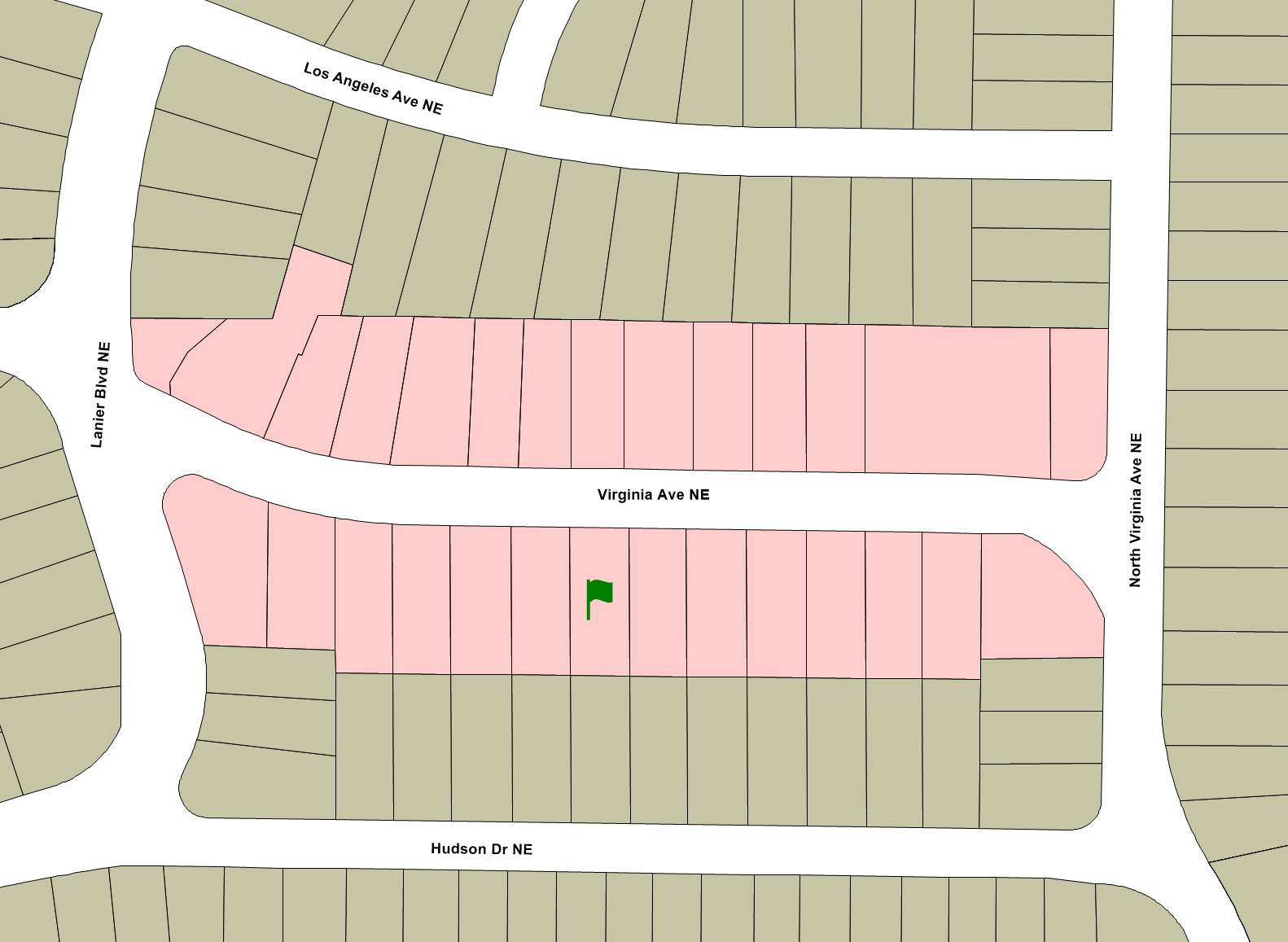
We typically think about a block in terms of the physical street. If you ask someone where they live, they might respond with something like, “the 1000 block of Virginia Avenue” which also happens to be the city block shown here in Figure 1:
Figure 1: Example City Block
If you lived, for example, in the house marked with the green flag, you would probably consider everyone on both sides of your street as living on your block, i.e., all of the parcels marked in red. But the Census Bureau has a very different understanding of your block. Your Census block excludes some people you would consider to be close neighbors: the house directly across the street with the blue flag, for example. And it would include some whom you wouldn’t consider to be close neighbors: every parcel marked in green would be in the same Census block as the house with the green flag, while the blue parcels would form the Census block belonging to the blue flag, as shown in Figure 2:
Figure 2: Example Census Blocks
Another way to think of it is as follows: if you take your dog for a walk around the block without crossing the street, all of the sidewalks you walk belong to the houses in your Census block.
It may seem odd that the Census Bureau defines blocks differently than you or I typically think about them, until you consider how they came about. Not that long ago, most Census data was collected by “enumerators” who administered the Census questions face-to-face. These enumerators were instructed to walk around an entire block without crossing the street because reduced the likelihood of missed houses or any double-counting. They then wrote the responses down on large forms[1] like this one from 1930 (featuring my grandfather in line 1 shortly after he came through Ellis Island):
Figure 3: Sample Population Schedule, 1930 Census
A second reason why blocks are drawn this way is to help with their ultimate purpose. The Census Bureau needs to be able to report data for small geographic units that can be easily described with (reasonably) permanent visible features– most commonly streets, but when those are unavailable, streams, rivers, or even powerlines and pipelines will do. The only exception is that blocks split at the city limits even if there isn’t any visible feature.[2]
The Census Bureau then uses these as the building blocks for all other geographies: blocks nest into block groups, which nest into tracts, which nest into counties (or county equivalents such as parishes in Louisiana or territories in Alaska), which nest in turn into states (or state equivalents such as Puerto Rico or the District of Columbia). Other sorts of geographic units such as cities do not fit cleanly into this hierarchy: the city of Atlanta, for instance is part in Fulton County, and part in DeKalb. Similarly, metropolitan areas can include counties from more than one state. But all of these geographies can be described perfectly in terms of a set of Census blocks.
The Decennial Census data tabulated to the block level is used to draw Congressional and state legislative districts. Again, these can span multiple tracts, cities, or even counties, but they are always collections of Census blocks.
Nerd Alert: Every Census block in the U.S. can be uniquely identified by a 15-digit code. The first two digits tell you the state. The numbers are assigned in alphabetical order; Georgia is 13. The next three digits denote the county within the state, again assigned in numerical order. For example, DeKalb is 089, while Fulton is 121. The next six digits identify the Census tract[3], while the final four identify the block within the tract. The first digit of that final four grouping has a special meaning: it indicates the block group number for that particular block.
Footnotes:
[1] The 1930 enumeration form measured 23¾” x 16½” (!).
Metro Atlanta adopts official new slogan. What say you, ATL? Josh GreenTue, 04/23/2024 - 14:55
The annals of Atlanta history include several great, poignant slogans—“Empire City of the South” comes to mind—and also more questionable taglines that aimed to sum up a disparate, ever-changing city and region in just a few words.
Following an extensive testing process, the metro now has an official new four-word brand. Drumroll…
“Atlanta – Where You Belong”
That’s according to the Metro Atlanta Chamber, which unveiled the slogan today as a means of attracting and retaining talented people across the 29-county metro in the face of growing competition among cities and regions.
Whether the branding sticks like “ATL” or comes and goes like “Every Day is an Opening Day” remains to be seen.
Midtown and downtown Atlanta in 2020. Shutterstock
According to MAC officials, a data-driven process of “exhaustive market research” informed the new brand’s selection, each step of its development overseen by an advisory group of senior marketing executives who are part of MAC’s board.
Those individuals—all with local connections—represent some of the largest brands on the planet, including Coca-Cola, Delta Air Lines, and Equifax.
The four-word brand “capitalizes on the region’s momentum as it continues to rise as a global center for innovation and opportunity” and a hub for “career opportunities and community connections,” per MAC’s announcement. “[The metro] provides a customizable life for any life stage, and has a community for everyone.”
MAC is partnering with Dagger, an Atlanta-based creative agency, to help spread the “Atlanta – Where You Belong” message across multiple platforms.
Before we all rush out and buy “Atlanta – Where You Belong” bumper stickers and T-shirts, let’s ask ourselves how the slogan stacks up to others throughout history:
You have said the dangers of the biodiversity crisis are equal to or even greater than the climate crisis. Can you elaborate?
If we stop emitting carbon dioxide, climate change could be stopped or reversed. But if we lose species, they’re gone forever.
We’ve seen species extinction and the degradation of ecosystems proceed at a rapid pace. We’re losing species at a rate of about anywhere from 100 to 1,000 times faster than the background rate, based on previous extinctions. Addressing climate change will remove one threat to biodiversity, but it won’t stop its decline. If we fix climate change tomorrow, we still are dealing with a massive degradation of nature and biodiversity.
Nature is infinitely more complex than a molecule of carbon. We’re coming up with ways to deal with carbon. But nature is more complex, so we’re still learning a great deal.
When we lose ecosystems or genetic diversity, that impacts our ability to survive as a human species, not to mention all the other more-than-human species that inhabit the planet with us. The food we eat, the air we breathe, the water we drink, the medicines we use are all directly related to nature. If we lose nature, we’re going to severely impact all the things that keep us alive and thriving.
While we look to the sky trying to figure out what to do with climate change, nature is being pulled out right from under us.
Conserving and managing at least 30 percent of the world’s lands, inland waters, and coastal areas is something we’re directly involved in and we take to heart every day.
The targets include four overarching goals, including: the “integrity and connectivity and resilience of all ecosystems are maintained, enhanced, or restored, sustainably increasing the area of natural ecosystems by 2050.” This is where landscape architects can have the greatest impact. We’re all involved and can help make sure this goal is met.
The 23 targets can be put into four categories. One is on-the-ground action targets. The other is policy initiatives. The third is financing and capacity building. The fourth deals with inclusion and equity.
At Biohabitats, we’re really focused on the on-the-ground actions. That’s conserving habitat and species. It’s restoring ecosystems, managing invasive species, and adapting and mitigating to climate change. We deal with these on all our projects. But you can’t think of any of these global targets independently. They’re all connected to one another.
Our work also falls into the inclusion and equity batch of targets. We think about Indigenous peoples, communities of color, and underserved communities and make sure these communities not only participate in the work we do, but have the ability to make decisions, deciding what’s going to happen in their neighborhood, communities, and on their land with their consent.
How can landscape architects better design projects to achieve the 2030 biodiversity targets? What are the top three actions landscape architects can take to increase biodiversity in their work?
First, protect and conserve the biodiversity within your sphere of influence.
Second, restore biodiversity, which can take many forms. Look at how the site is connected to the rest of the landscape from a landscape ecology perspective. Seek to understand how nutrients cycle and flow through the site, how water interacts with the site, how species move across the site or inhabit the site, and how that’s all connected to the regional landscape. It’s really hard to increase biodiversity on a site if we don’t understand these connections and relationships.
Third, once you have an idea of what you’re going to protect and what you’re going to conserve, then develop ideas and ways to restore and enhance biodiversity. This can take the form of many different strategies and measures.
Landscape architects have a tremendous influence and impact on the way biodiversity is protected, conserved, restored, and enhanced.
Biodiverse landscapes provide a range of ecosystem services, including carbon sequestration. But with growing climate impacts like wildfires, landscapes can also become major sources of emissions. Biohabitats analyzed the carbon storage capacity of a fire-prone landscape for the City of Boulder, Colorado. What did you learn?
We were commissioned by the City of Boulder to look at whether their annual carbon sequestration in their open spaces and mountain parks would help them offset the carbon they emit as a city. We inventoried the carbon stock, and annual flux of their landscape, and projected what the loss may be based on fire or another land disturbances, and what the landscape’s potential is in terms of sequestering carbon under a changing climate and with the application of nature-based solutions.
We looked at over 36,000 acres. We found these lands had a really large existing carbon stock. 2.8 million cubic tons of carbon were already being stored in those landscapes.
Map illustrates areas with the greatest carbon density based on soils and landcover. Biohabitats. City of Boulder Open Space and Mountain Parks. Sustainability Solutions Group / Biohabitats
The grasslands had the greatest existing carbon storage, mostly in their soils. Wetlands actually had a greater carbon density per acre, but they cover relatively small areas. While the forest and grasslands can store significant amount of carbon in the landscape, our modeling of fire scenarios found that they were also a potential source of carbon emissions due to the risk of loss under certain scenarios.
We found that nature-based solutions could help draw down carbon and reduce loss. For example, prescribed burning can be used to improve landscape resilience. Because when fire-evolved ecosystems aren’t burned, the fires burn with more intensity and typically burn the soil as well. With frequent fires, you get less intensity, and they produce less carbon emissions.
This fell in line with other studies around the world. It also emphasized why developing or tilling greenfields is destructive in terms of carbon emissions. Protecting and conserving wild lands and parks is really important in reducing carbon emissions.
To the untrained eye, some of your firm’s projects look natural, like nothing has been done. Your beautiful project at Teaneck Creek Park in Bergen County, New Jersey, restored 46 acres of freshwater wetlands. Big Marsh Park on the South Side of Chicago restored a dumping ground and treats wastewater, but looks pristine. Is that one of your measures of design success — for your work to read as nature?
A quick story: We worked on a stream and riparian restoration project in Columbia, Maryland, which sits between Baltimore and Washington, D.C. in the 1990s. A reporter contacted us and said “I want to go out and take some pictures of the site you restored.” We told them where it was, and they went out. We got a call the next day saying they couldn’t find it. They were standing exactly at the point where we did the restoration.
With a lot of our restoration work, we hope it blends back into the existing landscape. But it goes a little bit deeper than that. We think about how to restore ecological processes, like food webs, hydrologic or nutrient cycles, ecological succession or disturbance regimes like fire. That’s what we focus on, not necessarily what the landscape’s going to look like.
It’s really place dependent. Every place has these processes, but they operate at different levels, scales, complexities, and relationships. A long grass prairie, an eastern deciduous forest, or a Gulf Coast tidal wetland are different. We’re trying to first understand those processes and design to protect, restore, enhance them.
If we start doing that, then that manifests itself into what the landscape is going to look like; what the plant community is going to look like; how water flows through, over, under the site; how species interact with the landscape; and how the site evolves. We’re trying to mimic ecosystem processes within landscapes that are relatively stable and intact. Much like architects or landscape architects use precedent images, we use reference landscapes.
Sand seepage wetlands at Teaneck Creek Park provide stormwater attenuation and water quality filtration while enhancing local biodiversity. Biohabitats. Bergen County Dept. Of Parks. Teaneck Creek Conservancy. Rutgers’ Center for Urban Environmental Sustainability / David Ike PhotographyTeaneck Creek Park. Biohabitats. Bergen County Dept. Of Parks. Teaneck Creek Conservancy. Rutgers’ Center for Urban Environmental Sustainability / David Ike Photography
For us, there’s an inherent beauty in natural systems. We’re trying to create the building blocks that allow natural systems to regenerate. For a landscape to be sustainable, robust ecological processes need to be in place. Otherwise, the system is going to fall apart.
The Ford Calumet Environmental Center in Big Marsh Park, designed by Valerio Dewalt Train, is home to Chicago’s first decentralized wastewater treatment and disposal system. The system, designed by Biohabitats, includes constructed wetlands, which demonstrate environmental stewardship while serving and improving access to nature. Biohabitats. Chicago Park District Valero Dewalt Train Associates. DbHMS Engineering. Jacobs/Ryan Associates / Tom Harris
We also work in highly disturbed landscapes that are disconnected from natural processes — for example, brownfields or high-density urban areas. While our goal is to restore the full suite of ecosystem processes and functions, many times we are quite limited in what we can do.
Scientists are calling these novel ecosystems. It’s the idea that we can use these reference landscapes as an analog but knowing that we’ll never be able to replicate many of the ecological processes that sustain these landscapes. What can we restore that has a semblance of ecological integrity and provides value to the life of that landscape? That’s where we begin.
It goes back to our tagline: “We’re in the business of restoring the future, not the past.” We can’t go back to the past because there have been so many changes to our landscapes, ecosystems, and planetary systems. We need to look forward.
Your firm works with the Army Corps of Engineers, which has a large contingent of landscape architects. What do you think that the Corps needs to do to fully realize its vision of Engineering with Nature?
We’ve been working with the Corps of Engineers for almost 30 years. I will give a shout-out to Dr. Todd Bridges, who, with his cohort of researchers and other practitioners, developed the Engineering with Nature initiative while he was at the U.S Army Engineer Research and Development Center (ERDC). Todd is now with a team of researchers at the University of Georgia, working in collaboration with the Corps and others to advance the idea of nature-based solutions for infrastructure projects all over the world.
In 2022, the ERDC contributed to The White House roadmap for accelerating nature-based solutions. This roadmap lays out five recommendations that the Corps and all federal agencies need to do. For the Corps, this will require Congress to change Corps policies, reallocate funding, and shift priorities. It’s not that the Corps is necessarily trying to make things more difficult or put-up roadblocks. Literally, they can’t do many of the changes we want to see or do until Congress gives them authorization. It’s up to all of us to advocate to our representatives in Congress to make these changes happen.
For example, the Corps has specific guidelines on how they evaluate project alternatives, which give overwhelming preference to damage reduction and business loss reductions. These are worthy benefits, but for the most part they completely ignore ecological and social benefits. It’s hard for the Corps to justify the use of nature-based solutions if the benefit is not quantifiable.
But just this past February, the Corps released a final rule to change that policy. If this rule is adopted, the Corps will be able to develop project alternatives that maximize environmental and public benefits. This allows both quantitative and qualitative data to be used in determining the highest benefit to lowest cost ratio. This alone will accelerate the application of nature-based solutions and aesthetic and context sensitive design considerations in infrastructure projects throughout the country. This could be a game-changer.
Your firm also integrates nature into dense urban environments, like a green street in downtown D.C. How do these small projects provide opportunities to increase biodiversity?
We’ve been working with the Golden Triangle Business Improvement District in D.C. for several years. We’re designing and retrofitting bioretention facilities into the streetscape. Obviously, as landscape architects, we are excited to see bioretention as a stormwater quantity and quality management system being designed and installed all over the world.
The idea of bioretention was developed by Larry Coffman in Prince George’s County, Maryland, a suburb just outside of Washington, D.C. in the early 1990s. Biohabitats was fortunate enough to have worked with Larry on that research, the design specifications, and proof of concept for the very first bioretention facilities in the world. So, this is sort of the homecoming for us.
Stair-stepping bioretention cells provide opportunities to showcase native diversity in the Golden Triangle neighborhood of Washington, DC. Biohabitats. Golden Triangle Business Improvement District. DC Department of Energy & Environment. Triangle Contracting. TCG Property Care. Timmons Group Insight LLC / Biohabitats
There are many benefits. Bioretention systems improve water quality by removing pollutants through soil microbes and uptake by plants. They infiltrate stormwater into the ground and help replenish groundwater. They reduce runoff off from impervious surfaces, particularly when designed with trees. They help reduce the heat island effect. And they also provide micro-habitats for pollinator species and migratory song birds, among other species. Bioretention facilities are wonderful ways to benefit nature and biodiversity in urban areas.
Lastly, in 2023, Biohabitats transitioned ownership from being a privately-held company to a perpetual purpose trust, much like Patagonia did. How did you decide this was the best way to achieve your long-term goals for your team and the planet?
Yes, on Earth Day, 2023, Biohabitats sold all its shares to the Biohabitats Purpose Trust (BPT), which is a non-charitable trust with the explicit purpose of “restoring nature, protecting and conserving biodiversity and inspiring love for wild places.”
I began looking a different options for ownership transition about seven years ago. I looked at selling Biohabitats to our team members, another firm, or private equity. I also considered an employee stock ownership plan, a co-op, and a variety of hybrid business models. Eventually, I came across the concept of a perpetual purpose trust through a business group I belonged to. The idea of locking in our purpose and mission in perpetuity really appealed to me and our team.
With the BPT, Biohabitats’ purpose, mission, and values are locked in for the next 100 plus years and cannot be bought or sold. Under the BPT, Biohabitats operates as a for-profit company trading as C-corporation, with a Benefit Corporation overlay. We are also B-Corps certified, a JUST company, and 1% for the Planet Member. The profits Biohabitats earns are no longer extracted by shareholders, because the BPT is the only shareholder and doesn’t need profits. Instead, profits get reinvested back into our team members, stakeholders, and nature.
The BPT is governed by a board of trustees within the Trust Earth Stewardship Committee, which is responsible for making sure that Biohabitats is meeting its purpose and objectives. There are five seats on this stewardship committee, and we have designated and legally codified one seat for nature. Nature, represented by a nature guardian, has a seat at the table and more importantly, agency in making sure that Biohabitats is meeting its purpose and objectives. We believe it’s the first time in the U.S. that nature has been legally assigned as trustee. For the wild!
At first glance, it might seem difficult to come up with many similarities between Taipei and its Sister City, Atlanta.
The Taiwanese capital has five metro lines that moves millions of people a day. Metro Atlanta’s daily rider numbers just hit 200,000. Despite carrying an endless stream of cars and motorcycles each day, Taipei’s roads are immaculate. Atlanta’s are seemingly always halfway sinking.
But what connects the sprawling metro area of Taiwan with its Atlanta counterpart is a shared commitment to Smart City initiatives. The Metro Atlanta area has become a hub for Smart City innovation, from Peachtree Corners’ Smart City living laboratory to new innovations coming out of Georgia Tech. Taipei and its surrounding municipalities have long been Smart City leaders and technology “solutions providers” to other places, said National Development Council’s Minister Ming-Hshin Kung during the opening ceremonies of the Smart City Summit & Expo last month.
“Taiwan has become a very important partner to cities around the world” when it comes to developing the infrastructure and technology associated with Smart City projects, added Paul Peng of the Taipei Computer Association. Taiwan is home to the world’s largest logic semiconductor companies and companies that are driving telecommunications innovation. It is also the birthplace of a growing number of Smart City startups, thanks to organizations like Startup Terrace and the country’s Ministry of Economic Affairs.
For the last eleven years, the international Smart City community has gathered in Taipei to see up-and-coming Smart City technology initiatives in action. The goal is to showcase Taiwanese innovations and learn from other Smart City leaders about what technologies are driving cities forward.
More than 500 leaders from 112 cities around the world took part in the Summit this year. Among them was a delegation of technologists and politicians from the State of Georgia. The delegation, which included Mayors from Woodstock and Warner Robins, took the opportunity to meet with companies and city leaders to further grow their Smart City initiatives at home.
So, What Makes A Smart City?
At its core Smart Cities, or Intelligent Cities, focus on using data to help improve the quality of life for its constituents. But as highlighted throughout the Summit, it is really about creating an Urban System Framework where governance, design, economics, and infrastructure all help build up a city’s culture and society.
CityGPT on the Expo floor
Cutting-edge Smart City programs were on full display at the Summit, with companies and municipalities showcasing what they are building in E-Governance, IoT (Internet of Things), Smart Energy, IoT Surveillance, and Smart Healthcare. The Georgia Delegation specifically got to spend time getting acquainted with each city counterparts and local companies that are building city-focused technologies. That included talking with city officials at places like Taoyuan, Taiwan who are using new AI technology to monitor local water pollution, companies like Foxconn developing a “CityGPT” to synchronize city data into one space, or startups working on new energy solution opportunities.
The Summit also highlighted the fact that Smart Cities need to focus on public-private partnerships, equitability, and leveraging human expertise in order to create thriving spaces.
The Summit was also a place for international representatives to exchange ideas. The Georgia Delegation, which included Mayor’s from Metro Atlanta cities Warner Robins and Woodstock, got to share on stage how they are leveraging data to build safer, more resilient cities. Their Smart City efforts were also celebrated, as both cities made the Smart21 list, a global award from the Intelligent Community Forum.
Michal Jensby and Mayor LaRhonda Patrick of the Georgia Delegation on the Expo floor
From Expo Floor To The Real World
But seeing Smart City examples on the floor of an Expo is one thing. It is something else to be able to experience how it impacts lives on a daily basis.
One representative from the Georgia Delegation certainly experienced that one night while grabbing dinner near the crowded Zhongxiao Fuxing Station. After taking a cab ride back to her hotel room, Global Atlanta’s Michal Jensby realized she couldn’t find her phone.
“When you lose your phone in the US and it’s been over half an hour, you know you’ll never see it again.You just start planning for how you’ll get another phone as soon as possible. I’m already thinking about how in the world I’m going to purchase a new phone and connect it to my US-provider account while in Taipei or if I’m going to have to go the whole business trip without a phone,” she told Hypepotamus.
Upon the suggestion of her hotel’s concierge, Jensby and her friend went down to the local police station. They were greeted by an officer who ushered them over to a computer monitor in the lobby of the building that to Jensby’s surprise, the screen showed every CCTV camera on every major intersection of Taipei, with a Google Map-style user experience allowing the police officer to Zoom in on different cars. Despite not have the exact license plate for the cab — and having very little identifying information other than a general time in which the cab left the restaurant and arrived at the hotel — they were able to track down the phone in less than twenty minutes.
“[It was] starting to feel like I’ve honestly become a secret agent. The amount of transparency we have into this situation baffles me, and the whole time we’re searching footage, I’m saying to my friend — “Isn’t it crazy that we’re watching this? Isn’t it crazy that they can sit here for half an hour and help me find my phone because no one had their car stolen, no one got shot, no one broke into a building nearby?” Jensby added.
“This whole ordeal happened the first night I landed and it affected the way I thought about Smart Cities and my perspective on the conference. I still wonder what everyday Taiwanese citizens feel or even know about the amount of surveillance and data collection happening, but I saw the efficiency and value of having this technology available when I needed it.”